


Wayfinding relates to the decision-making process while going from one place to another and making important decisions along the way that help to traverse the path. We constantly confirm our position while approaching a destination or a nearby location. This is an integral part of our day-to-day lives.
Indian cities are laid out in a very different way than the grid-like structures of western cities. We have an organic growth of infrastructure in most of the cities. The reliance on maps for navigation has always been low; rather, asking around is the norm. What makes us comfortable with this way of navigating? One of the reasons is cultural. People are not used to maps. Giving directions in India is an idiomatic art, well-rehearsed but rarely done following formal strictures.
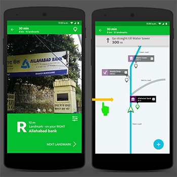
Nobody says, "Head south." Rather than oral directions, use a series of routes and familiar landmarks with additional information in the vicinity of the landmark to better guide the user.
Using this knowledge, a hypothesis was created revolving around the concept that if the existing way of moving people is used rather than pushing a solution that works well in grid-based cities, a simple yet familiar concept of wayfinding can be created with a focus on landmarks and the spatial distances between them.
The final concept focuses on implementing subjective wayfinding. Simply understand the user's mental model and offer a meaningful understanding of the environment that can be easily comprehended. This combines context-aware information about local landmarks with simple schematic maps imitating user behaviours in real life. Each upcoming landmark in the journey is combined with sound, image, and other data that makes the process more subjective and makes identifying and remembering landmarks easier. The solution helps the user to utilise local information that is available within a community and finally create a shared database of familiar routes.
In a simple schematic map, landmarks are used as guiding points from one checkpoint to another. Landmarks are points where a user can get oriented through visual and audio help. Each landmark has a corresponding image and other data associated with it. Users create routes and share them with the community. This collective effect makes available a larger depository of easy-to-follow maps that anyone can use and update.
For evaluation, users will be asked to reach destinations on selected routes using the design and other existing solutions. The aim is to know how comfortable users are finding destinations with the given interface and identifying landmarks to take turns and make routing decisions. How easily one can remember the route and create their own landmarks.
The design gives way to future work, including more rich data that can be kept up-to-date in a changing environment. Such designs can leverage our existing ways of problem solving and enhance them with technological intervention. We don’t need to change what already works well; rather, we should find a technological solution that can coexist with and complement what we already have.