


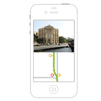
In India, where usage of printed maps is less and the reliance on asking around is higher, adaptation to existing online solutions is low. Asking around is influenced by several socio-cultural factors and in turn affects how wayfinding systems are designed. These include micro factors like the time of the day to macro factors like gender and personal biases. Using the hypothesis that a combination of schematic maps and landmark information will be an effective way of navigation, a prototype that uses these concepts was created. A combination of schematic maps that are widely used in transit networks and photographs of landmarks on the route can result in a new wayfinding system. Schematic maps are created using generalization techniques to make a map more usable and closer to users’ mental models. With the map showing the direction of travel, landmarks along the route can be used to move further and reach the intended destination. Here, landmarks along the route are used as checkpoints and nodal points. Checkpoints are intermediate milestones which the user has to achieve and nodal points are locations on the route where the user takes a turn from his current direction of travel. These are shown as points on the map and each of these have corresponding landmark photographs associated with them. Hence, the route is divided into segments that are completed in a sequential manner. Nodal points with several intersecting roads are provided with details of other routes to guide the users accordingly. The prototype created using the above concepts was tested in comparison with an existing solution (Google Maps) with users with less education. Some of these users were first-time map users. Two randomized sets of users—one using an existing solution and one using the current concept—were asked to reach a destination using the prototypes. A/B Testing was also conducted to avoid bias. During evaluation, users could use the application successfully with most of them being able to identify landmarks and reach the final destination without much hassle. Comparative studies showed that landmark-based navigation definitely has an edge over other systems, especially when it comes to taking the correct turn. Future work lies in creating a scalable model for generating data that will be required to make the application usable and keep it up-to-date with the changing environment.